There are two Southern Arizona USGS stream gages that have always intrigued us. One is the uppermost gage on the US side of The San Pedro down near the Mexican border. And the other is The Santa Cruz gage at Tubac.
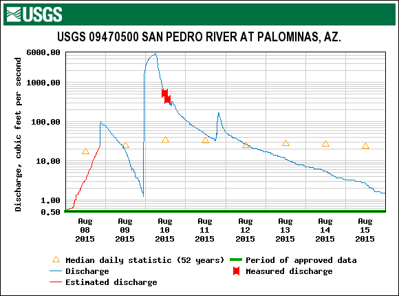
The Palominas Gage has a huge drainage area of over 700 square miles in Sonora, Mexico. Sometimes during monsoon, it can rain like crazy in Mexico and be bone dry in Arizona. By and by, a big slug of water barges across the border and rushes down The San Pedro. It's always quite a phenomena. Here are four graphics of the Palominas gage. The Tubac gage is below.
The Palominas gage looks like it should be pretty easy to find.
Here was the biggest flush of 2015. It burst upon the scene late the night of August and peaked on August 10. When the pulse hit, The San Pedro was running 1.2 cfs. When it peaked about 5:30 AM, it was running 5,520 cfs! What an awesome event.
The San Pedro rose 10+ feet in that event.
Here's how it looked every 15 minutes when the pulse hit.
OK, moving on to Tubac. Here's the location of the gage--should be easy-peasy to find.
The Tubac gage isn't as prone to dramatic spikes as Palominas but it's always very active during a normal monsoon season. Here are the volume and gage height graphs for the July 1-September 1, 2015 time period.


No comments:
Post a Comment